Local government
Leeds was a manor and township in the large ancient parish of Leeds St Peter, in the Skyrack wapentake of theWest Riding of Yorkshire.[26] The Borough of Leeds was created in 1207, when Maurice Paynel, lord of the manor, granted a charter to a small area within the manor, close to the river crossing, in what is now the city centre. Four centuries later, the inhabitants of Leeds petitioned Charles I for a charter of incorporation, which was granted in 1626. The new charter incorporated the entire parish, including all eleven townships, as the Borough of Leeds and withdrew the earlier charter. Improvement commissioners were set up in 1755 for paving, lighting, and cleansing of the main streets, including Briggate; with further powers added in 1790 to improve the water supply.[27]
The borough corporation was reformed under the provisions of Municipal Corporations Act 1835. Leeds Borough Police force was formed in 1836 and Leeds Town Hall was completed by the corporation in 1858. In 1866 Leeds, and each of the other townships in the borough, became a civil parish. The borough became a county borough in 1889, giving it independence from the newly formed West Riding County Council and it gained city status in 1893. In 1904 the Leeds parish absorbed Beeston, Chapel Allerton, Farnley, Headingley cum Burley and Potternewtonfrom within the borough. In the twentieth century the county borough initiated a series of significant territorial expansions, growing from 21,593 acres (87.38 km2) in 1911 to 40,612 acres (164.35 km2) in 1961.[28] In 1912 the parish and county borough of Leeds absorbed Leeds Rural District, consisting of the parishes of Roundhay andSeacroft; and Shadwell, which had been part of Wetherby Rural District. On 1 April 1925 the parish of Leeds was expanded to cover the whole borough.[26]
| 1881 | 160,109 |
|---|---|
| 1891 | 177,523 |
| 1901 | 177,920 |
| 1911 | 259,394 |
| 1921 | 269,665 |
| 1931 | 482,809 |
| 1941 | war # |
| 1951 | 505,219 |
| 1961 | 510,676 |
| # no census was held due to wa | |
The county borough was abolished on 1 April 1974 and its former area was combined with that of the municipal boroughs of Morley andPudsey; the urban districts of Aireborough, Horsforth, Otley, Garforth and Rothwell; and parts of the rural districts of Tadcaster, Wetherby andWharfedale.[29] This area was used to form a new metropolitan district in the county of West Yorkshire; it gained both borough and city status and is known as the City of Leeds. Initially, local government services were provided by Leeds City Council and West Yorkshire County Council. However, the county council was abolished in 1986 and the city council absorbed its functions, with some powers passing to organisations such as the West Yorkshire Passenger Transport Authority. From 1988 two run-down and derelict areas close to the city centre were designated for regeneration and formed the area of responsibility of Leeds Development Corporation, outside the planning remit of the city council.[30] Planning powers were restored to the local authority in 1995 when the development corporation was wound up.
Suburban growth
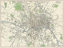
In 1801, 42% of the population of Leeds lived outside the township, in the wider borough. Choleraoutbreaks in 1832 and 1849 caused the borough authorities to address the problems of drainage, sanitation and water supply. Water was originally pumped from the River Wharfe, but by 1860 it was too heavily polluted to be usable. Following the Leeds Waterworks Act of 1867 three reservoirs were built at Lindley Wood, Swinsty and Fewston, to the north of Leeds.[31] Residential growth occurred in Holbeck and Hunslet from 1801 to 1851, but, as these townships became industrialised new areas were favoured for middle class housing.[32] Land to the south of the river was henceforth developed, primarily for industry and secondarily for back-to-back workers' dwellings. The Leeds Improvement Act 1866 sought to improve the quality of working class housing by restricting the number of homes that could be built in a single terrace.[33] Holbeck and Leeds formed a continuous built-up area by 1858, with Hunslet nearly meeting them.[34] In the latter half of the nineteenth century, population growth in Hunslet, Armley and Wortley outstripped that of Leeds itself. When pollution became a problem, the wealthier residents left the small industrial conurbation to live in the northerly villages of Headingley, Potternewton and Chapel Allerton; this led to a 50% increase in the population of Headingley and Burley from 1851 to 1861. The middle class flight from the industrial areas also led to development beyond the borough at Roundhay and Adel.[34] The introduction of the electric tramway led to intensification of development in Headingley and Potternewton and expansion outside the borough intoRoundhay.[35]
Two private gas supply companies were taken over by the corporation in 1870 and this new municipal supply was used to provide street lighting and cheaper gas to homes. From the early 1880s the Yorkshire House-to-House Electricity Company supplied electricity to Leeds until it was also purchased by Leeds Corporation and became a municipal supply.[36]
Slum clearance and rebuilding began in Leeds in the Inter-war period when over 18,000 houses were built by the council on 24 estates in places like Cross Gates, Middleton, Gipton, Belle Isle and Halton Moor. The slums of Quarry Hill were replaced by the innovative Quarry Hill flats, which were demolished in 1975. Another 36,000 houses were built by private sector builders, creating the suburbs of Gledhow, Moortown, Alwoodley, Roundhay, Colton, Whitkirk, Oakwood, Weetwood and Adel. After 1949 a further 30,000 sub-standard houses were demolished by the council to be replaced by a total of 151 medium-rise and high-rise blocks of council flats in estates like Seacroft, Armley Heights, Tinshill and Brackenwood.[37]
Recently, Leeds has seen great local expenditure on regenerating the city, attracting in investments and flagship projects,[38] as found inLeeds city centre. Many buildings have already been built, boasting luxurious penthouse apartments,[39] just a stones throw from the city centre. Recently, the Skyscraper Project has been put on hold, due to the global recession and overall downturn in the housing market. The building works are still planned to go ahead, despite very little recent change.

No comments:
Post a Comment