Geography
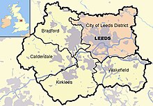
At 53°47′59″N 1°32′57″W (53.799°, −1.549°), and 190 miles (310 km) north-northwest of central London, the central area of Leeds is located on the River Aire in a narrow section of the Aire Valley, which is in the eastern foothills of the Pennines. The city centre lies at about 206 feet (63 m) above sea level while the district ranges from 1,115 feet (340 m) in the far west on the slopes ofIlkley Moor to about 33 feet (10 m) where the rivers Aire and Wharfe cross the eastern boundary. The centre of Leeds is part of a continuously built-up area extending to Pudsey, Bramley, Horsforth, Alwoodley, Seacroft, Middleton and Morley.[40] Leeds has the second highest population of any local authority district in the UK (after Birmingham), and the second greatest area of any English metropolitan district (after Doncaster), extending 15 miles (24 km) from east to west, and 13 miles (21 km) from north to south. The northern boundary follows the River Wharfe for several miles but crosses the river to include the section of Otley which lies north of the river. Over 65% of the Leeds district is green belt land and the city centre is less than twenty miles (32 km) from the Yorkshire Dales National Park,[41] which offers some of the most spectacular scenery and countryside in the UK.[42] Inner and southern areas of Leeds lie on a layer of coal measure sandstones. To the north parts are built on older sand and gritstones and to the east it extends into the magnesian limestone belt.[19][43] The land use in the central areas of Leeds is overwhelmingly urban.[40]

Attempts to define the exact geographic meaning of Leeds lead to a variety of concepts of its extent, varying by context; they include the area of the city centre, the urban sprawl, the administrative boundaries, and the functional region.[44]
Leeds city centre is contained within the Leeds Inner Ring Road, formed from parts of the A58 road, A61 road, A64 road, A643 road and theM621 motorway. Briggate, the principal north-south shopping street, is pedestrianised and Queen Victoria Street, a part of the Victoria Quarter, is enclosed under a glass roof. Millennium Square is a significant urban focal point. The Leeds postcode area covers most of the City of Leeds[45] and is almost entirely made up of the Leeds post town.[46] Otley, Wetherby, Tadcaster, Pudsey and Ilkley are separate post towns within the postcode area.[46] Aside from the built up area of Leeds itself, there are a number of suburbs and exurbs within the district.

Climate
Leeds has a temperate climate, with four distinct seasons. As with most of the eastern counties of England, Leeds is a relatively dry city, with an average of 660 mm of rain falling annually, which is drier than New York City, Sydney and Rome. Snowfall can occur from November - April, but is most common from January - March. When snowfall does occur, it rarely sticks on the ground for more than a few days. An exception to this would be the snowfall of 2009-2010, where there were several prolonged spells of continuous snow cover, particularly in late December and early January. Hard frost in winter is common and can occur any time from October-April.
Summers in Leeds are usually mild, with an average high of 20°C (69°F)[citation needed] , and occasionally exceed 25°C (77°F), and in 2003 & 2006, temperatures stayed above 25°C for several days[citation needed] , and even reached 30°C (86°F)[citation needed] , and were one of the hottest summers in the city since the 20th century. The summers of 2007-2009 were very wet, not just for Leeds, but for most of the UK, with high humidity and frequent thunderstorms, hail showers and floodin
Demography
Urban subdivision
At the time of the United Kingdom Census 2001, the Leeds urban subdivision occupied an area of 109 square kilometres (42 sq mi) and had a population of 443,247; making it the fourth most populous urban subdivision within England and the fifth largest within the United Kingdom. The population density was 4,066 inhabitants per square kilometre (10,530 /sq mi), slightly higher than the rest of the West Yorkshire Urban Area. It accounts for 20% of the area and 62% of the population of the City of Leeds. The population of the urban subdivision had a 100 to 93.1 female–male ratio.[50] Of those over 16 years old, 39.4% were single (never married) and 35.4% married for the first time.[51] The urban subdivision's 188,890 households included 35% one-person, 27.9% married couples living together, 8.8% were co-habiting couples, and 5.7% single parents with their children. Leeds is the largest component of the West Yorkshire Urban Area[40] and is counted by Eurostat as part of the Leeds-Bradford Larger Urban Zone. The Leeds travel to work area in 2001 included all of the City of Leeds, a northern strip of the City of Bradford, the eastern part of Kirklees, and a section of southern North Yorkshire; it occupies 751 square kilometres (290 sq mi).Metropolitan district
As of the 2001 UK census, the district had a total population of 715,402.[52] Of the 301,614 households in Leeds, 33.3% were married couples living together, 31.6% were one-person households, 9.0% were co-habiting couples and 9.8% were lone parents, following a similar trend to the rest of England.[53] The population density was 1,967 inhabitants per square kilometre (5,094.5/sq mi)[53] and for every 100 females, there were 93.5 males.The majority of people in Leeds identify themselves as Christian.[54] The proportion of Muslims (3.0% of the population) is average for the country.[54] Leeds has the third-largest Jewish community in the United Kingdom, after those of London and Manchester. The areas ofAlwoodley and Moortown contain sizeable Jewish populations.[55] 16.8% of Leeds residents in the 2001 census declared themselves as having "no religion", which is broadly in line with the figure for the whole of the UK (also 8.1% "religion not stated"). The crime rate in Leeds is well above the national average, like many other English major cities.[56][57] In July 2006, the think tank Reform calculated rates of crime for different offences and has related this to populations of major urban areas (defined as towns over 100,000 population). Leeds was 11th in this rating (excluding London boroughs, 23rd including London boroughs).[58] The table below details the population of the current area of the district since 1801, including the percentage change since the last available census data.
Governance
City of Leeds is the local government district covering Leeds and the local authority is Leeds City Council. The council is composed of 99 councillors, three for each of the city's wards. Elections are held three years out of four, on the first Thursday of May. One third of the councillors are elected, for a four year term, in each election. In 2004 all seats were up for election due to boundary changes. The council is currently under no overall control, and is run by a coalition of the Labour and Green councillors. West Yorkshire does not have a county council, so Leeds City Council is the primary provider of local government services for the city. The district is in the Yorkshire and the Humberregion of England, and consists of an unparished area and 31 civil parishes. These are the lowest tier of local government[60] and absorb some limited functions from Leeds City Council in their areas. The councils of Horsforth, Morley, Otley and Wetherby are town councils.[61]There are 27 other civil parishes in the district.The district is represented by eight MPs, for the constituencies of Elmet and Rothwell (Alec Shelbrooke, Conservative); Leeds Central (Hilary Benn, Labour); Leeds East (George Mudie, Labour); Leeds North East (Fabian Hamilton, Labour); Leeds North West (Greg Mulholland, Lib Dem); Leeds West (Rachel Reeves, Labour); Morley and Outwood (constituency shared with City of Wakefield) (Ed Balls, Labour); andPudsey (Stuart Andrew, Conservative). Leeds is within the Yorkshire and the Humber European constituency, which is represented by twoConservative, one Labour, one UKIP, one Liberal Democrat and one BNP MEPs. The voting figures for Leeds in the European Parliament election in June 2009 were: Conservative 22.6%, Labour 21.4%, UKIP 15.9%, Lib Dem 13.8%, BNP 10.0%, Green 9.4%.
At the time of the United Kingdom Census 2001, the Leeds urban subdivision occupied an area of 109 square kilometres (42 sq mi) and had a population of 443,247; making it the fourth most populous urban subdivision within England and the fifth largest within the United Kingdom. The population density was 4,066 inhabitants per square kilometre (10,530 /sq mi), slightly higher than the rest of the West Yorkshire Urban Area. It accounts for 20% of the area and 62% of the population of the City of Leeds. The population of the urban subdivision had a 100 to 93.1 female–male ratio.[50] Of those over 16 years old, 39.4% were single (never married) and 35.4% married for the first time.[51] The urban subdivision's 188,890 households included 35% one-person, 27.9% married couples living together, 8.8% were co-habiting couples, and 5.7% single parents with their children. Leeds is the largest component of the West Yorkshire Urban Area[40] and is counted by Eurostat as part of the Leeds-Bradford Larger Urban Zone. The Leeds travel to work area in 2001 included all of the City of Leeds, a northern strip of the City of Bradford, the eastern part of Kirklees, and a section of southern North Yorkshire; it occupies 751 square kilometres (290 sq mi).
Metropolitan district
As of the 2001 UK census, the district had a total population of 715,402.[52] Of the 301,614 households in Leeds, 33.3% were married couples living together, 31.6% were one-person households, 9.0% were co-habiting couples and 9.8% were lone parents, following a similar trend to the rest of England.[53] The population density was 1,967 inhabitants per square kilometre (5,094.5/sq mi)[53] and for every 100 females, there were 93.5 males.The majority of people in Leeds identify themselves as Christian.[54] The proportion of Muslims (3.0% of the population) is average for the country.[54] Leeds has the third-largest Jewish community in the United Kingdom, after those of London and Manchester. The areas ofAlwoodley and Moortown contain sizeable Jewish populations.[55] 16.8% of Leeds residents in the 2001 census declared themselves as having "no religion", which is broadly in line with the figure for the whole of the UK (also 8.1% "religion not stated"). The crime rate in Leeds is well above the national average, like many other English major cities.[56][57] In July 2006, the think tank Reform calculated rates of crime for different offences and has related this to populations of major urban areas (defined as towns over 100,000 population). Leeds was 11th in this rating (excluding London boroughs, 23rd including London boroughs).[58] The table below details the population of the current area of the district since 1801, including the percentage change since the last available census data.
Governance
City of Leeds is the local government district covering Leeds and the local authority is Leeds City Council. The council is composed of 99 councillors, three for each of the city's wards. Elections are held three years out of four, on the first Thursday of May. One third of the councillors are elected, for a four year term, in each election. In 2004 all seats were up for election due to boundary changes. The council is currently under no overall control, and is run by a coalition of the Labour and Green councillors. West Yorkshire does not have a county council, so Leeds City Council is the primary provider of local government services for the city. The district is in the Yorkshire and the Humberregion of England, and consists of an unparished area and 31 civil parishes. These are the lowest tier of local government[60] and absorb some limited functions from Leeds City Council in their areas. The councils of Horsforth, Morley, Otley and Wetherby are town councils.[61]There are 27 other civil parishes in the district.The district is represented by eight MPs, for the constituencies of Elmet and Rothwell (Alec Shelbrooke, Conservative); Leeds Central (Hilary Benn, Labour); Leeds East (George Mudie, Labour); Leeds North East (Fabian Hamilton, Labour); Leeds North West (Greg Mulholland, Lib Dem); Leeds West (Rachel Reeves, Labour); Morley and Outwood (constituency shared with City of Wakefield) (Ed Balls, Labour); andPudsey (Stuart Andrew, Conservative). Leeds is within the Yorkshire and the Humber European constituency, which is represented by twoConservative, one Labour, one UKIP, one Liberal Democrat and one BNP MEPs. The voting figures for Leeds in the European Parliament election in June 2009 were: Conservative 22.6%, Labour 21.4%, UKIP 15.9%, Lib Dem 13.8%, BNP 10.0%, Green 9.4%.
As of the 2001 UK census, the district had a total population of 715,402.[52] Of the 301,614 households in Leeds, 33.3% were married couples living together, 31.6% were one-person households, 9.0% were co-habiting couples and 9.8% were lone parents, following a similar trend to the rest of England.[53] The population density was 1,967 inhabitants per square kilometre (5,094.5/sq mi)[53] and for every 100 females, there were 93.5 males.
The majority of people in Leeds identify themselves as Christian.[54] The proportion of Muslims (3.0% of the population) is average for the country.[54] Leeds has the third-largest Jewish community in the United Kingdom, after those of London and Manchester. The areas ofAlwoodley and Moortown contain sizeable Jewish populations.[55] 16.8% of Leeds residents in the 2001 census declared themselves as having "no religion", which is broadly in line with the figure for the whole of the UK (also 8.1% "religion not stated"). The crime rate in Leeds is well above the national average, like many other English major cities.[56][57] In July 2006, the think tank Reform calculated rates of crime for different offences and has related this to populations of major urban areas (defined as towns over 100,000 population). Leeds was 11th in this rating (excluding London boroughs, 23rd including London boroughs).[58] The table below details the population of the current area of the district since 1801, including the percentage change since the last available census data.
Governance
City of Leeds is the local government district covering Leeds and the local authority is Leeds City Council. The council is composed of 99 councillors, three for each of the city's wards. Elections are held three years out of four, on the first Thursday of May. One third of the councillors are elected, for a four year term, in each election. In 2004 all seats were up for election due to boundary changes. The council is currently under no overall control, and is run by a coalition of the Labour and Green councillors. West Yorkshire does not have a county council, so Leeds City Council is the primary provider of local government services for the city. The district is in the Yorkshire and the Humberregion of England, and consists of an unparished area and 31 civil parishes. These are the lowest tier of local government[60] and absorb some limited functions from Leeds City Council in their areas. The councils of Horsforth, Morley, Otley and Wetherby are town councils.[61]There are 27 other civil parishes in the district.
The district is represented by eight MPs, for the constituencies of Elmet and Rothwell (Alec Shelbrooke, Conservative); Leeds Central (Hilary Benn, Labour); Leeds East (George Mudie, Labour); Leeds North East (Fabian Hamilton, Labour); Leeds North West (Greg Mulholland, Lib Dem); Leeds West (Rachel Reeves, Labour); Morley and Outwood (constituency shared with City of Wakefield) (Ed Balls, Labour); andPudsey (Stuart Andrew, Conservative). Leeds is within the Yorkshire and the Humber European constituency, which is represented by twoConservative, one Labour, one UKIP, one Liberal Democrat and one BNP MEPs. The voting figures for Leeds in the European Parliament election in June 2009 were: Conservative 22.6%, Labour 21.4%, UKIP 15.9%, Lib Dem 13.8%, BNP 10.0%, Green 9.4%.
No comments:
Post a Comment