Economy
Leeds has a diverse economy with employment in the service sector now far exceeding that in the traditional manufacturing industries. In 2002, 401,000 employees were registered in the Leeds district. Of these 24.7% were in public administration, education and health, 23.9% were in banking finance and insurance and 21.4% were in distribution, hotels and restaurants. It is in the banking, finance and insurance sectors that Leeds differs most from the financial structure of the region and the nation.[63] The city is the location of one of the largest financial centres in England outside London.[64][65][66][67][68][69] Tertiary industries such as retail, call centres, offices andmedia have contributed to a high rate of economic growth. The city also hosts the only subsidiary office of the Bank of England in the UK. In 2006 GVA for city was recorded at £16.3 billion,[70] with the entire Leeds City Region generating an economy of £46 billion.[71]
The extensive retail area of Leeds is identified as the principal regional shopping centre for the whole of the Yorkshire and the Humber region and approximately 3.2 million people live within its catchment area.[72] There are a number of indoor shopping centres in the middle of the city, including the Merrion Centre, Leeds Shopping Plaza, St John's Centre, Headrow Centre, theVictoria Quarter, The Light and the Corn Exchange. In total there are approximately 1,000 retail stores, with a combined floorspace of 2,264,100 square feet (210,340 m2).[72] Of the 40,000 people who work in retailing in Leeds 75% work in places which are not located in the city centre. There are additional shopping centres located in the many villages that became part of the county borough and in the towns that were incorporated in the City of Leeds in 1974.[73]
Office developments, also traditionally located in the inner area, have expanded south of the River Aire and total 11,000,000 square feet (1,000,000 m2) of space.[72] In the period from 1999 to 2008 £2.5bn of property development was undertaken in central Leeds; of which £711m has been offices, £265m retail, £389m leisure and £794m housing. Manufacturing and distribution uses accounts for £26m of new property development in the period. There are 130,100 jobs in the city centre, accounting for 31% of all jobs in the wider district. In 2007, 47,500 jobs were in finance and business, 42,300 in public services, and 19,500 in retail and distribution. 43% of finance sector jobs in the district are contained in Leeds city centre and 44% of those employed in the city centre live more than nine kilometres away.[72] Tourism is important to the Leeds economy, in 2009 Leeds was the 8th most visited city in England by UK visitors.[74] and the 13th most visited city by overseas visitors.

Landmarks
Leeds displays a variety of natural and built landmarks. Natural landmarks include such diverse sites as the gritstone outcrop of Otley chevin and the Fairburn Ings RSPB reserve. The city's parks at Roundhay and Temple Newsam have long been owned and maintained by the council for the benefit of ratepayers and among the open spaces in the centre of Leeds are Millennium Square,Leeds City Square, Park Square and Victoria Gardens. This last is the site of the central city war memorial: there are 42 other war memorials in the suburbs, towns and villages in the district.[76]
The built environment embraces edifices of civic pride like Morley Town Hall and the trio of buildings in Leeds, Leeds Town Hall, Corn Exchange and Leeds City Museum by the architectCuthbert Brodrick. The two startlingly white buildings on the Leeds skyline are the Parkinson building of Leeds University and the Civic Hall, with golden owls adorning the tops of its twin spires.[77] Armley Mills, Tower Works, with its campanile-inspired towers, and the Egyptian-styleTemple Works hark back to the city's industrial past, while the site and ruins of Kirkstall Abbey display the beauty and grandeur of Cistercianarchitecture. Notable churches are Leeds Parish Church, St George's Church and Leeds Cathedral, in the city centre, and the Church of St John the Baptist, Adel and Bardsey Parish Church in quieter locations.
The 110 metres (360 ft) tower of Bridgewater Place, also known as The Dalek, is part of a major office and residential development and the region's tallest building; it can be seen for miles around.[78] Among other tower blocks the 37-storey Sky Plaza to the north of the city centre stands on higher ground so that its 105 metres (344 ft) is higher than Bridgewater Place. With 37 floors it is reported to be the tallest student residential building in the world.[79]
Elland Road (football) and Headingley Stadium (cricket and rugby) are well known to sports enthusiasts and the White Rose Centre is a well known retail outlet.

Transport
Leeds is the starting-point of the A62, A63, A64, A65 and A660 roads, and is also situated on the A58 and A61. The M1 and M62 intersect to its south and the A1(M) passes to the east. Leeds is one of the principal hubs of the northern motorway network. Additionally, there is an urban motorway network; the radial M621 takes traffic into Central Leeds from the M62 and M1. There is an Inner Ring Road with part motorway status and an Outer Ring Road. Part of the city centre[80] is pedestrianised, and is encircled by the clockwise-only Loop Road.


Public transport in the Leeds area is coordinated and developed by West Yorkshire Metro,[81] with service information provided by Leeds City Council[82] and West Yorkshire Metro. The primary means of public transportation in Leeds are the bus services. The main provider is First Leeds andArriva Yorkshire serves routes to the south of the city. Leeds also offers a free bus, the FreeCity Bus service. Leeds City bus station is at Dyer Street and is used by bus services to towns and cities in Yorkshire, plus a small number of local services. Adjacent to it is the coach station forNational Express coach services. Buses out of the city are mainly provided by FirstBus and Arriva Yorkshire. Harrogate & District provides a service to Harrogate and Ripon. Keighley & Districtprovides a service to Shipley, Bingley and Keighley. The Yorkshire Coastliner service runs from Leeds to Bridlington, Filey, Scarborough and Whitby via York and Malton. Stagecoach provides a service to Hull via Goole.
From Leeds railway station at New Station Street, MetroTrains operated by Northern Rail run to Leeds' suburbs and onwards to all parts of Leeds City Region. The station is one of the busiest in England outside London, with over 900 trains and 50,000 passengers passing through every day.[83] It provides national and international connections as well as services to local and regional destinations. The station itself has 17 platforms, making it the largest in England outside London.[84]
Leeds Bradford International Airport is located in Yeadon, about 10 miles (16 km) to the north-west of the city centre, and has both charter and scheduled flights to destinations within Europe plusEgypt, Pakistan and Turkey. There are connections to the rest of the world via London Heathrow Airport, Paris Charles de Gaulle Airport and Amsterdam Schiphol Airport.There is a direct rail service from Leeds to Manchester Airport. Robin Hood Airport Doncaster Sheffield is 40 miles (64 km) south-east of Leeds. Leeds has connections by road, rail and coach to Hull, only an hour away, from where it is possible to travel to Rotterdam and Zeebrugge by ferry services run by P&O Ferries.
Walking
The Leeds Country Way is a waymarked circular walk of 62 miles (100 km) through the rural outskirts of the city, never more than 7 miles (11 km) from City Square. The Meanwood Valley Trail leads from Woodhouse Moor along Meanwood Beck to Golden Acre Park. The Leeds extension of the Dales Way follows the Meanwood Valley Trail before it branches off to head towards Ilkley and Windermere. Leeds is on the northern section of the Trans Pennine Trail for walkers and cyclists, and the towpath of the Leeds and Liverpool Canal is another popular walking route. In addition, there are many parks and public footpaths in both the urban and rural parts of Leeds, and the Ramblers' Association, YHA and other walking organisations offer sociable walks. The Ramblers' Association publish various booklets of walks in and around Leeds.[85]
Education
At the time of the 2001 census Leeds had a population of 183,000 young people aged 0–19 of whom 110,000 were attending local authority schools.[86] In 2008 Education Leeds, a non-profit company owned by Leeds City Council, provided for 220 primary schools, 39 secondary schools and 6 special inclusive learning centres.[87] Under the government Building Schools for the Futureinitiative, Leeds secured £260m, to transform 13 secondary schools into high achieving, e-confident, inclusive schools. The first three of these schools at Allerton High School, Pudsey Grangefield School and Rodillian School, were opened in September 2008.[88] Because Leeds has a falling birth rate, the council have come under pressure in recent years to reduce the number of school places resulting in the merger and closure of some schools. The city's oldest and largest private school is The Grammar School at Leeds, which was legally re-created in 2005 following the merger of Leeds Grammar School, established 1552, and Leeds Girls' High School, established 1857. Other independent schools in Leeds include faith schools serving the Jewish[89] and Muslim[90] communities.
Further and higher education
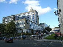
Further education is provided by Leeds City College (formed by a merger in 2009 and having over 60,000 students), Leeds College of Building, Joseph Priestley College in Morley and Notre Dame Catholic Sixth Form College. The city has two universities: the University of Leeds received its charter in 1904 having developed from the Yorkshire College which was founded in 1874 and the Leeds School of Medicine of 1831, and Leeds Metropolitan University became a university in 1992 but can trace its roots to the Mechanics Institute of 1824. The University of Leeds has a total of about 31,000 students, of which 21,500 are full-time or sandwich undergraduate degree students,[91] Leeds Metropolitan University has a total of 52,000 students of which 12,000 are full time or sandwich undergraduate degree students and 2,100 full time or sandwich HND students.[92] Other higher education establishments are:Leeds Trinity University College with just under 3,000 students,[93] Leeds College of Art, Leeds College of Music and Northern School of Contemporary Dance. The city was voted the Best UK University Destination by a survey in The Independent newspaper.[94] The combined totals of learners give Leeds one of the largest student populations in the country with over 250,000 students.[95]

No comments:
Post a Comment