Friday, October 29, 2010

Photo Gallery: London's Financial District

Photo: Paternoster Square, London

London

Photo: Buckingham Palace guards
Members of the Grenadier Guards march through the gates of Buckingham Palace.


The United Kingdom’s capital city—covering 610 square miles (1,580 square kilometers)—is huge. Founded in A.D. 43, it’s also old. And powerful. London is a hub of culture, business, and politics—and center of the once glorious British Empire that can still throw its weight around the globe. Served by a fabulous subway system, numerous tour buses, and the iconic black taxis, London is not difficult to find your way around in. And despite the city’s enormity, the center is small enough to make walking a good option—just mind the warnings painted on the curb to look right when crossing the street. Drivers come at you, unexpectedly, along the left side of the road


London Must-Dos


Photo: The London Eye

The British Museum
Built around the 1857 Round Reading Room, "Norman Foster's Great Court is a wonderful contrast of old London with new. Afterward, wander through the Egyptian rooms and look at the mummies."—Hannah Duguid, an arts writer atThe Independent. Great Russell Street; tel. 44 (0) 207 323 8299.www.thebritishmuseum.ac.uk
The Gagosian
Larry Gagosian's cavernous second London gallery is "an amazing space. They barely advertise but get big names (Giacometti, Twombly, Koons) you'd pay to see at the Tate, and it's free."—Mat Osman, musician and editor of le cool London. 6-24 Britannia St., Kings Cross; tel. 44 (0) 207 841 9960.www.gagosian.com
Hampstead Heath
"Wonderfully wild environment right in central London. Just wander and get lost."–Mark Sladen, director of exhibitions, Institute of Contemporary Arts. "No major sights, but a real sense of history. Pretty potters and dress designers in charming backstreets of Hampstead Village."—Henrietta Green, founder ofwww.foodloversbritain.com. Hampstead Lane; tel. 44 (0) 208 348 1286.www.english-heritage.org.uk
The London Library
"Saunter in and take out a first-edition Shakespeare folio."—Stephen Bayley, design consultant and author. Over one million books and periodicals dating back to the 16th century, in fabulous period premises. 14 St James's Square, Mayfair; tel. 44 (0) 207 930 7705. www.londonlibrary.co.uk
Sir John Soanes Museum
"The best place to get lost in London."—Stephen Bayley. Vast, varied collection of art and architecture crammed into three town houses. "A cabinet of curiosities, a very personal and eccentric product of its maker."—Mark Sladen. Candlelit tours 6-9 p.m. first Tuesday of each month. 13 Lincoln's Inn Fields; tel: 44 (0) 207 405 2107. www.soane.org
St. Paul's Cathedral
"As London's skyline evolves, with the prevailing climate of vertiginous architectural ambition, Wren's cupola remains the iconic feature of the city's landscape. Finest place to give into the airy seduction of a bird's-eye view of the city."—Jack Lohman, director, Museum of London. Be prepared to climb 530 steps to the top. Ludgate Hill; tel. 44 (0) 207 236 4128. www.stpauls.co.uk
Victoria and Albert Museum
Founded in 1852, this treasure trove of fine art and design covers 3,000 years and every continent. Fabulous gift shop and art nouveau café overlooking serene courtyard with sculpture. Cromwell Rd, South Kensington; tel. 44 (0) 207 942 2000. www.vam.ac.uk
William Morris Gallery
"Wonderful testament to the polymath talents of one of England's finest designers. Unrivaled collection of Morris's work in fabrics, furniture, glass, and ceramics. Deserves much wider public recognition."—Jack Lohman. Worth a trek to Walthamstow. Lloyd Park, Forest Road; tel: 44 (0) 208 527 3782.
Cabinet War Rooms
A small door surrounded by sandbags leads to the underground bunkers from which Winston Churchill conducted military operations while air raids rocked London. Locked in 1945 and re-opened in 1984, everything is intact from the campaign maps to Churchill's encrypted hotline to FDR. A history lesson frozen in time. Clive Steps, King Charles St.; tel. 44 (0) 207 930 6961.

Monday, October 25, 2010

Abercarn - Wales

Abercarn is a small town[2] community in Caerphilly county boroughWales, 10 miles (16 km) north-west of Newport on the A467 between Cwmcarn and Newbridge, within thehistoric boundaries of Monmouthshire.


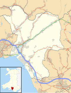
Abercarn is located in Caerphilly

History

The district was traditionally associated with the coal mining collieries, ironworks and tinplateworks of the South Wales coalfield and South Wales Valleys, although all have now closed;[3]the town, which lies in the middle portion of the Ebbw valley, being situated on the south-eastern flank of the once great mining region of Glamorgan and Monmouthshire.[4]
On 11 September 1878 it was the site of an underground explosion which killed 268 coal miners.[5]

Local government


The area was part of the ancient Monmouthshireparish of Mynyddislwyn until the late 19th century. In 1892 a local board of health and local government district of Abercarn was formed.[6] This became Abercarn urban district in 1894, governed by an urban district council of twelve members. Under the Local Government Act 1972 the urban district was abolished in 1974, becoming part of the borough of IslwynGwent. Further local government organisation in 1996 placed the area in the county borough of Caerphilly. The former urban district corresponds to the three communities of Abercarn, Crumlin andNewbridge.

Sport

Abercarn is home to Abercarn Rugby Club which is a member of the Welsh Rugby Union.


Aberbargoed - Wales


Aberbargoed (WelshAberbargod) is a small town in the Welsh county borough of Caerphilly, within the historic boundaries ofMonmouthshiresouth Wales.
Aberbargoed once contained the largest ever colliery waste tip in Europe, although this has now been reclaimed and turned into a country park.

Mining

Coal mining operations in Bargoed Colliery started in 1897 when the Powell Duffryn Steam Coal Company started to sink the shaft. In 1901, the "Ras Las" nine-foot seam was discovered at a depth of 625 yards. The north and south shafts were completed. In November 1903, Sir Alfred Thomas, M.P. for East Glamorgan, started the engines to raise the first four trams of coal.
By 1910, the pit was employing 1,943 miners and was the largest coal mine in the Rhymney Valley. On 10 December 1908, it broke the world record for production when a ten-hour shift produced 3,562 tons of coal. It further broke its own record on 23 April 1909 when 4,020 tons were raised in a ten-hour shift.
Bargoed Colliery closed on 4 June 1977. By this time, only 360 men were employed there.

Population

The population of Pont Aberbargoed was 351 in the census of 1851. Aberbargoed reached a peak in 1961 of 5,157, and had dropped to 3,882 according to the 1991 Census. Bargoed in 1921 had a population of 17,901, dropping to 9,184 by 1991.

Modern Day

The coal-mining waste tip that lay between Bargoed and Aberbargoed once towered to a height of 400 feet in the 1970s. The local school had a "Plant a tree in '73 campaign" in an attempt to make it more pleasurable on the eye. The tip has now been levelled and the area has been reclaimed with walkways. The colliery has gone and is now home to an Ambulance Station and other small industries.
There are also developments with a new retail outlet in the area where the tip once stood. The large tip at Bedwellty is still there, but has been grassed over and now looks much like the surrounding countryside.
Aberbargoed now has an extensive area of grasslands that are protected due to the finding of a rare butterfly: the Marsh fritillary Euphydryas aurinia has been found in the marshy area north of where Bedwellty School once stood. Recently a bypass has been built through the park allowing road users to bypass the town of Bargoed.

Notable people

Heolddu Comprehensive School (1994). Bargoed Bygones. Heolddu Comprehensive School.
James, Paul (2002). The History of Bargoed, Gilfach and Aberbargoed in Photographs, Vol. 3. Old Bakehouse Publications. ISBN 1 874538 64 6.
Gelligaer Historical Society (1972). Gelligaer. Gelligaer Historical Society.

Aberavon -Wales

Aberavon (WelshAberafan) is a settlement in Neath Port Talbot county boroughWales. The town derived its name from the river Afan, which also gave its name to a medievallordship. Today it is essentially a district of Port Talbot, covering the central and south western part of the town. Aberavon is also the name of the nearby Blue Flag beach and theparish covering the same area.
Aberavon is located in Neath Port Talbot


History

On the Normans conquest of Glamorgan, Caradog, the eldest son of the defeated Welsh prince, Iestyn ab Gwrgant, continued to hold this lordship, and for the defence of the passage of the river built a castle whose foundations now lie underneath the streets around St Mary's church. His descendants (who from the 13th century onwards styled themselves De Avan or D'Avene) established, under line protection of the castle, a chartered town, which in 1372 received a further charter from Edward le Despencer, 1st Baron le Despencer, into whose family the lordship had come on an exchange of lands. In modern times these charters were not acted upon, the town being deemed a borough by prescription, but in 1861 it wasincorporated under the Municipal Corporations Act.
Aberavon was the birthplace of Dic Penderyn, a key figure in the Merthyr Rising of 1831. St Mary's Church is the site of his grave.
From 1832 Aberavon belonged to the Swansea parliamentary district of boroughs, uniting withKenfigLoughorNeath and Swansea to return one member; since 1918 it has had its own constituency. Its most famous MP was Ramsay MacDonald.
In the 1950s many of the sand dunes of Aberavon Beach disappeared as part of the development of the Sandfields estate, at this time a 1.25 mile sea wall was built primarily for sea defences. The estate was built to accommodate the growing population, especially the families of workers at the new Port Talbot Steelworks.
Aberavon hosted the National Eisteddfod in 1932 and 1966.


Sport

Aberavon RFC are a rugby union team, and play in the Welsh Premier Division, which is the top tier of the Welsh rugby pyramid.
Aberavon Green Stars RFC are a rugby club based in Sitwell Way Aberavon. [1]
One of Aberavon's rugby league clubs is called the Aberavon Fighting Irish and play in the Welsh Conference Premier.


Baglan Industrial Park

The Baglan Bay Industrial Park lies on a stretch of Baglan Moors in the parish of Aberavon south east of the Baglan Energy Park and immediately northwest of Neath Port Talbot Hospital. It is sandwiched between the M4 Motorway and Afan Way (A4241). Current occupants include MorrisonsLidlKFCFocus DIYDreamsPound StretcherPets at Home & Halfords superstores and a Warburtons bread factory in premises which were previously occupied by Panasonic.

Government and politics

The electoral ward of Aberavon is coterminous with district of Aberavon and is a part of the parliamentary constituency of Aberavon.
Aberavon is bounded by the wards of Sandfields West and Sandfields East to the southwest; Baglan to the north; Port Talbot to the east and Margam to the south. The ward boundaries can be defined by the roads surrounding it which are the M4 Motorway to the north east; the A4241 to the north west; Afan Way to the southwest and the River Afan to the south east.
The Aberavon ward can be roughly divided into two parts. There is the residential area to the southeastern part of the ward beside the River Afan. The north western area consists of areas of industrial estate land called the Baglan Industrial Park which includes a number of out of town retail premises as well as business and manufacturing premises.


Aberaeron-wales

Aberaeron (EnglishMouth of the River Aeron) is a seaside resort town in Ceredigion,WalesPopulation 1,500. Situated between Aberystwyth and Cardigan, it is home to the headquarters of Ceredigion County Council.


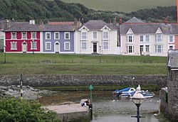
AberaeronHouses.jpg

History and design

Aberaeron was planned and built in 1805 by the Rev. Alban Thomas Jones. It is built around the estuary of the River Aeron, which has been enlarged to provide a small half-tide harbourfor recreational craft. The estuary is also crossed by a wooden pedestrian bridge.
In the late 1890s, a hand-powered cable car 'The Aeron Express' was built to ferry workers across the harbour when the bridge was demolished by floods. The structure was recreated in the late 1980s as a tourist attraction that ran until the end of summer 1994.
The architecture of Aberaeron is unusual in this part of rural Wales, being constructed around a principal square of elegant Regency style buildings grouped around the harbour. Some of the architecture was of sufficient interest to feature on British postage stamps
Aberaeron is located in Ceredigion

Location and features


Aberaeron is located between Cardigan and Aberystwyth on the A487, at a junction with theA482 leading south-east to the university town of Lampeter.
The shoreline consists of generally steep storm beaches of pebbles, although fine sand is visible at low tide levels. Aberaeron south beach was awarded the Blue Flag rural beach award in 2005[1].
The climate is mild and temperate, largely conditioned by the proximity of the relatively shallow sea. However, Aberaeron can suffer from occasional winter frosts when cold air descends the Aeron valley from the upland parts of Ceredigion.
The town is notable for the sale of honey and especially honey ice-cream and more recently honey mustard.
70% of Aberaeron's inhabitants are able to speak Welsh according to the 2001 census.
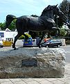
A life-sized statue of a Welsh cob stallion was donated to the town in 2005 by the Aberaeron Festival of Welsh Ponies and Cobs to denote the area as Welsh Cob country. It was created by sculptor David Mayer.
Dylan Thomas' links with Aberaeron, New Quay and Talsarn have been documented by local author David N Thomas[2]The Dylan Thomas Trail runs through Ceredigion, passing through Aberaeron and ending in New Quay[3]
There is also an annual carnival which takes place every Bank Holiday Monday in August A pressesion starts on the Quay and ends up in the Alban Square.

Famous residents

Image gallery